South of Great Smoky Mountain National Park, the Appalachian Trail crosses a large section of North Carolina that is dominated by Nantahala National Forest. Part of the allure of this section is three balds that offer breathtaking views of the surrounding mountains. This hike encompassed two of them with an exploratory trek to another bald to see what I could see. I began the day early in frigid temperatures at Wayah Bald. Because people can drive up to it and it is the location of a historic fire tower, I wanted to beat the crowds.

The fire tower has a long, evolving history. On many higher elevations peaks in the early 1900's, lookout towers were constructed to watch for fires. On Wayah bald, a wooden tower was erected in 1929. That was replaced in 1937 by an elaborate stone three story tower built by the CCC. Visitors could look out in each direction from the second story and the third provided the living quarters and communications equipment for the watchers on duty. After cracks were discovered in the rocks walls, use as a fire tower was abandoned in 1945 and the top two stories were removed in 1947. A concrete slap was poured on top of the first level to stabilize it for visitor viewing. In 1983, the forest service built a roof over the platform to bring it to it's present state.

Wayah bald is unique in that the Appalachian Trail and Bartram Trail coincide. The Bartram trail is a trail of 116 miles that traverses natural areas of North Georgia and Western Carolina. It commemorates travels of naturalist William Bartram in the 1770s. According to my topo map, the trails led to another bald named Wine Spring Bald. Since I hike to see what is there, I headed in that direction.


Driving back down the forest road to Wayah Gap for part two of my hike, I stopped at the historic Wilson Lick Ranger Station (which is also accessible via AT by a short spur trail). Built in 1916, it was the first in the newly formed Nantahala National Forest. The ranger station, shed and remains of an outhouse are preserved with signs telling the history through old photographs. This was a sweet stop for lunch before crossing to the other side of the gap for my ascent on Siler Bald.

The first challenge to ascending Siler Bald is parking. There is a picnic area with a small parking lot and a short, narrow adjacent forest service road that were crammed with cars on this ideal fall day. Hiking up through the picnic area, I caught the Appalachian Trail along with a few hundred others. Two of the hikers I heard a quarter mile away thanks to their booming bluetooth speaker. (People, PLEASE be considerate of others!). Just over a mile and a half on the AT, I reached Snowbird Gap and the spur trail that goes up the meadow to the top of Siler Bald.

The trek up Siler Bald Vista Trail is only 1/4 mile but it is steep enough to seem like much more. Many less enthusiastic hikers may decide the views halfway up are good enough.

Finishing the climb though provides not just the satisfaction of the accomplishment and the opportunity to take a picture of the marker, it also rewards one with views of the south and southwest.


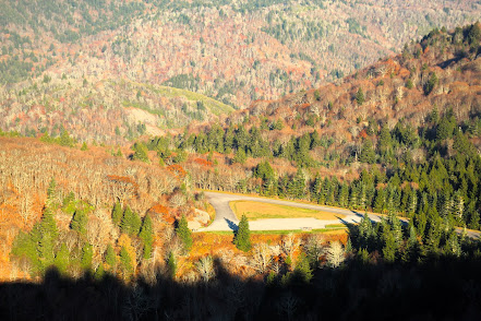
Looking back in the direction I came from (above picture), I could pick out the summit and tower on Wayah Bald (right) and cell towers on Wine Spring Bald (left). Heading back down to the AT, I turned right which went to the woods on other side of clearing. Here, the AT goes right with a spur trail to the shelter a short distance ahead. Another trail (which my topo showed as a gated road that returned to parking area) went straight. I went straight on a steep and rocky trail that I had to myself. At a point where it turned left, the shelter spur trail went right so I figured I would see what the shelter looked like. On the way there, I heard and saw two deer in a field off to my left. I stood still and waited for them. They cautiously approached the trail a good distance away and then darted across. I continued on to the shelter and then backtracked, following the path of the former road back to the parking lot. Although still steep, that section was at least recognizable as an old road bed and made a nice loop hike.